(Inactive) Network Center for Community Change (Louisville)
May 2011
Image:
Collected data in a study area within the California neighborhood using property evaluation forms that our team created. We noted condition of housing, vacant housing and vacant lots. We mapped the study area in ArcMap and layered our observed data with data sets we already had. The map is presented in PDF format to show the many layers of data that has been collected. So far, this map has been presented to California community groups and partners of the organization. Our next step for this mapping project will be to collect qualitative data from residents living in the study area and
University Center for Social and Urban Research (Pittsburgh)
2011
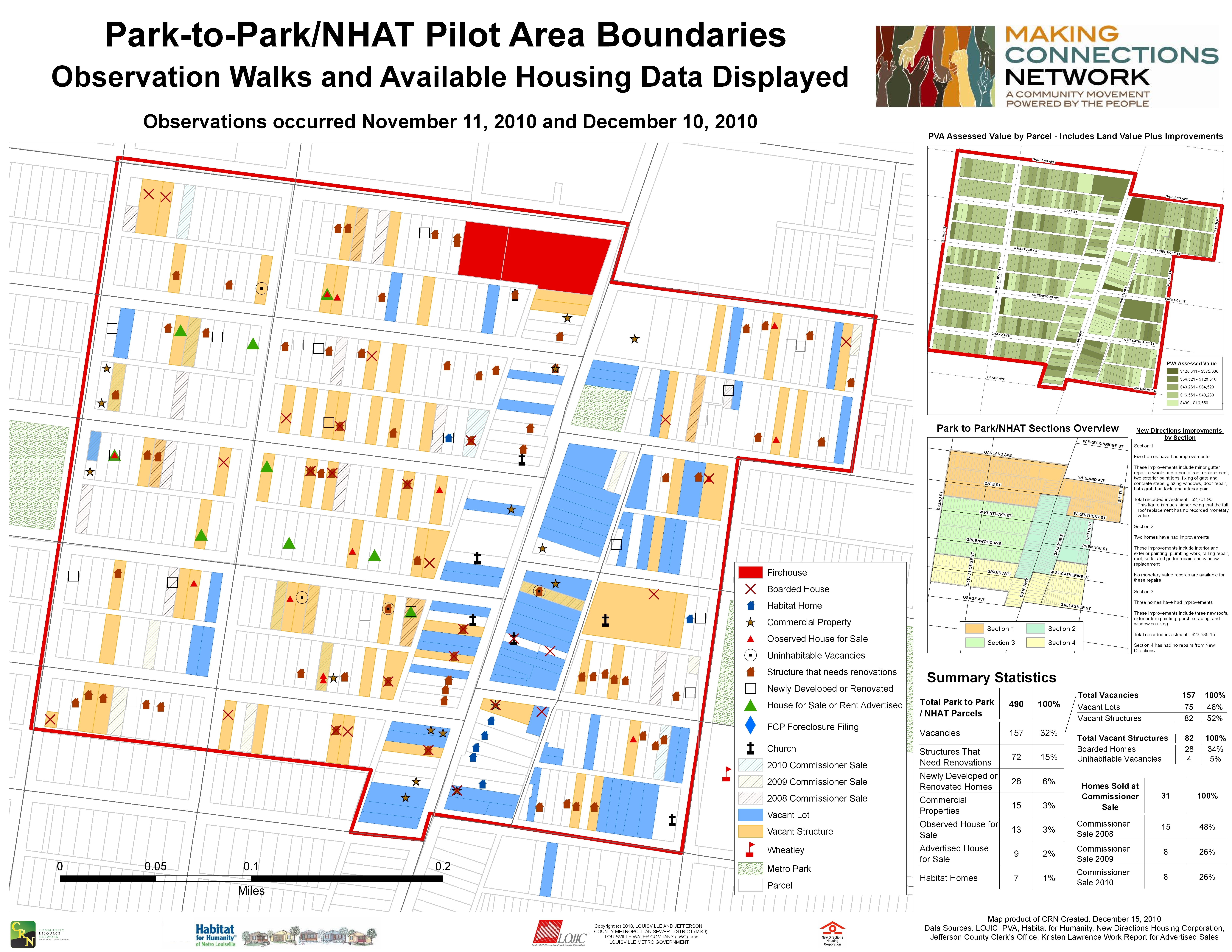
The PNCIS is supporting the work of the Homewood Children's Village, an initiative working to improve the environment for children and families in the Homewood neighborhood. The PNCIS is being used to document neighborhood conditions, develop a vacant land management strategy, and create instruments for collecting visual property survey data.
In partnership with Urban Institute, we convened a group of key policy makers around the second edition of Housing in the New Orleans Metro Annual Report, “Optimizing Blight Strategies”. Speakers included Kathy Petit from the Urban Institute, Allan Mallach from the Center for Community Progress, and Allison Plyer from GNOCDC.
CamConnect is pursuing funding to begin Camden’s first regularly updated citywide survey of vacant and suspected vacant properties. Abandonment has long been one of Camden’s most visible symptoms of urban decline, and their pervasive presence has led to social fragmentation and a perpetual sense of hopelessness for residents and businesses alike. By combining geo-data from our survey with public and private administrative data, CamConnect hopes to establish a baseline for documenting and tracking the city’s abandonment problem and improve the city’s capacity for real property management.
With assistance from the Pohlad Family Foundation, CURA hired a graduate research assistant to help compile a comprehensive database of vacant properties in North Minneapolis. Data comes from City registered vacant & boarded buildings, neighborhood windshield surveys, zero water usage data, USPS undeliverable addresses, foreclosures and developer held for rehab info. The second phase of this project will be developing strategies for addressing the various types of vacancy in order to help stabilize neighborhoods hardest hit by the aftermath of the foreclosure crisis.
The Greater New Orleans Community Data Center relies on three different sources for USPS data‚ all of which are based on the USPS Address Management Services database: HUD (Department of Housing and Urban Development) Aggregated USPS Administrative Data on Address Vacancies; the Valassis Residential and Business Database‚ and the USPS Delivery Statistics Product.
You can read all about these and find links to publications with more detailed information in Appendix A of our Benchmarks for Blight brief.
Center on Poverty and Community Development (Cleveland)
February 13, 2012
WEWS Channel 5 news did a feature on NEO CANDO and the Poverty Center's work related to foreclosure and vacancy in Cuyahoga County. Both Dr. Claudia Coulton and Mike Schramm were interviewed for the story.
University Center for Social and Urban Research (Pittsburgh)
March 1, 2012 to August 31, 2012
The PNCIS was part of a team selected to prepare a plan for vacant properties in Pittsburgh's Hill District neighborhood. Our work will involve the collection of parcel-based data in the Hill District, including property assessment, ownership, land use, tax, and sales records to paint a full picture of vacant property in the Hill District. The project will begin in March 2012.
University Center for Social and Urban Research (Pittsburgh)
February 1, 2012
Working with the Congress of Neighboring Communities (CONNECT) at the University of Pittsburgh, we are seeking to expand the coverage of the PNCIS to additional municipalities in Allegheny County by developing a sustainable model for gathering and using data across multiple jurisdictions.
The Federal Reserve Bank of Richmond and the Federal Reserve Board are co-hosting an interactive conference in Baltimore, Maryland on creative uses of data and technology to promote public and private investment in transitional communities. The purpose of the convening is to bring together community stakeholders to discuss ways of using data to make more strategic neighborhood stabilization decisions given limited resources. This conference helps to highlight the overall NNIP model as well as partners efforts locally. It will feature discussions with local NNIP partners from Baltimore, Cl
In 2010, D3 developed a composite analysis of indicators to illustrate the land use category of each Census Block in the city. This typology analysis is based upon current conditions, not solely zoning or land use, and also illustrates the relative strengths and challenges between different blocks. In 2011, D3 served as a technical partner as CDAD and community groups piloted the framework process in Southwest Detroit with Urban Neighborhood Initiatives and on the Eastside with the Lower Eastside Action Plan.
(Inactive) Center for Community Building and Neighborhood Action (Memphis)
April 2012
Originally funded by a grant from the US Department of Justice and designed by CBANA/C3R (working with the Southeast Memphis CDC and Ledic Asset Management) , “Safeways” is a data-driven supportive collaboration among owner/managers, residents, law enforcement, and non-profits to improve safety and quality of life in multifamily housing communities. Owners/managers access training and technical assistance in place management and resident services, and may apply for Safeways Certification.
The Urban Affairs Association has presented the award for the "Best Conference Paper of 2013" to Erica Raleigh, director of Data Driven Detroit, and George Galster for their paper entitled "Neighborhood Disinvestment, Abandonment and Crime Dynamics".
• Steven Adler, Information Strategist, IBM • Jerry Paffendorf, Co-Founder and CEO, LOVELAND Technologies • Erica Raleigh, Director, DataDrivenDetroit • David Edinger, Chief Performance Officer, City of Denver
Check out our first Idea Showcase of 2015 and work your fellow NNIP partners are doing:
Eleanor Tutt (St. Louis) and Bob Gradeck (Pittsburgh) will present on their idea to hold regular NNIP Twitter Chats. Jessica McInchak (Detroit) will present on their work on Urban Innovators and Josh Wheeling will demonstrate Camden's new vacancy map.
Plus, their will be updates from NNIPHQ including a brief review of the guide we just produced for partners who host NNIP Meetings.
One of the most important new means for sharing data with the public is our Open Data Site, launched in “beta” form in the spring of 2014. We have been using the tool to publish existing data in our warehouse, prioritizing new content uploads as data requests come from the community through “Ask D3” and as project-related files are completed. We leveraged the Motor City Mapping project to strengthen our ability to provide accessible data to the community at large.
In 2009, Data Driven Detroit (D3) participated in the Detroit Residential Parcel Survey (DRPS), collecting data on roughly 350,000 structures and vacant lots in the city of Detroit. The survey captured information on the physical condition of Detroit’s residential neighborhoods and empty lots. Eventually, passage of time rendered the DRPS dataset less representative of current conditions in the city and thus less useful for decision-makers. In the winter of 2013, the Motor City Mapping project once again undertook the collection of parcel-level data in Detroit. Using teams of resident s
University Center for Social and Urban Research (Pittsburgh) Baltimore Neighborhood Indicators Alliance (Baltimore) Center on Poverty and Community Development (Cleveland)
The Urban Institute and the Data Center in New Orleans partnered from 2009-2011 do three annual reports related to housing funded by the local community foundation. The organizations divided up the analysis and writing tasks to complete the report, and the Data Center took the lead on dissemination and community engagement.
CI:Now’s new Viz-a-lyzer is an interactive tool for people to visually explore and analyze (visual… viz… viz-a-lyze… get it?) Bexar County data by zip code tract area and year, with comparisons to Bexar County, Texas, and the United States where available. We’ll be adding new indicators and features several times a year – subscribe to our newsletter to hear when a new release is out.
Following the foreclosure crisis, Oakland faced a serious problem of an increasing number of vacant buildings. Vacant properties, particularly if not well-maintained, can negatively affect the safety and quality of life in a neighborhood and the resulting lower property values reduce the wealth of remaining homeowners. The acquisition of foreclosed properties by investors who either keep the property vacant to sell later and/or are irresponsible about property upkeep can produce similarly harmful neighborhood effects.
Wednesday, January 1, 2020 to Saturday, January 1, 2022
The Community Innovation and Action Center (CIAC) worked alongside St. Louis City departments and the region’s largest home repair providers to shed light on a problem...
Neighborhood data counts people. It counts the places that our communities hold dear, and it counts the tragedies that we wish never happened. Neighborhood data counts how many of us have library cards, how many songs we sing along to on the way to work, and how many new mothers received prenatal care. It counts how our neighborhood is changing - when a new apartment building is constructed, a coffee shop is opened, or a new mural is painted.
Community Innovation and Action Center (CIAC) (St. Louis)
2024
The Community Innovation and Action Center (CIAC) is partnering with the St. Louis Vacancy Collaborative, a local community-based initiative, on a two-year initiative to develop a vacancy strategy with/for the City of St. Louis.